Context
Urban areas are at the forefront of climate change impacts, facing unique challenges due to their density, infrastructure, and complex interactions with the natural environment. As cities grow and urbanization accelerates worldwide, understanding and managing urban climate dynamics becomes increasingly critical.
Adaptation measures are crucial for transitioning cities toward greater resilience. However, the effectiveness of these measures hinges on access to comprehensive urban climate data, which is often limited or inconsistently available across different regions.
Tailored climate information, spanning historical trends, current conditions, and future projections, is essential for accurately assessing climate change impacts and designing effective adaptation strategies that address the unique needs of each urban area.

Solution
Access to detailed urban climate information is essential to enhance urban resilience in the face of climate change. However, a critical barrier to effective urban planning and adaptation is the scarcity of comprehensive and localized urban climate data.
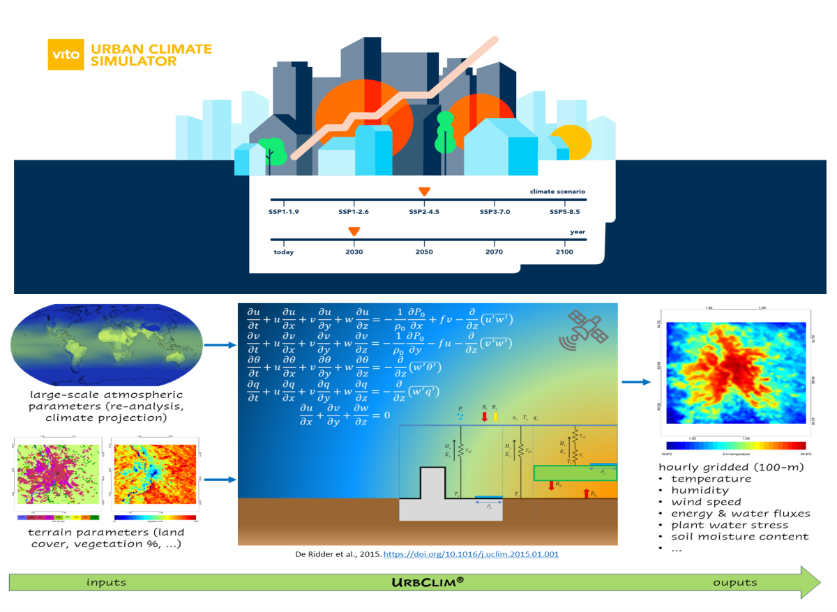
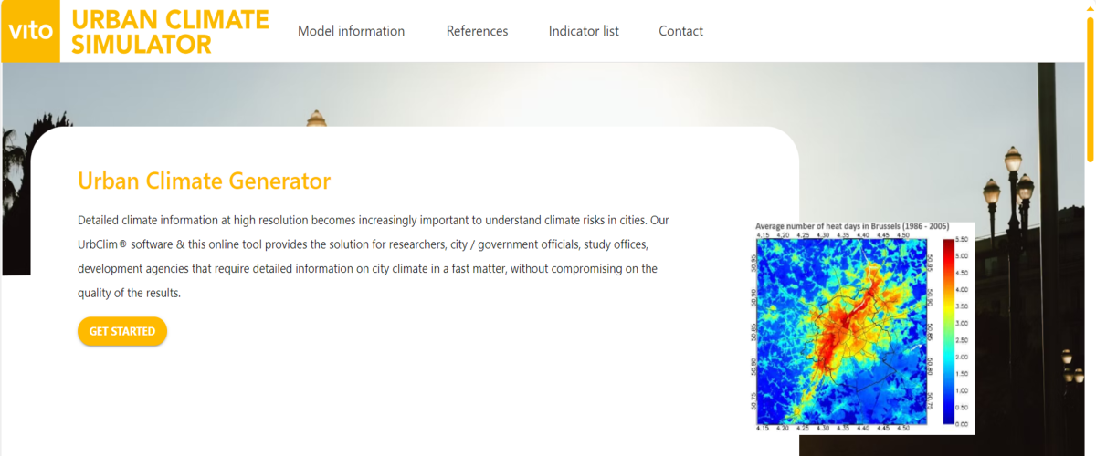
UrbSim, the Urban Climate Simulator, is a web tool based on VITO's UrbClim@ software that offers a solution for researchers, city/government officials, technical and environmental consulting companies, study offices, development agencies and climate investors that require detailed information on the city climate in a fast way, without compromising on the quality of the results.
The UrbClim@ model has already been applied in hundreds of cities around the world in several projects to underpin and motivate urban climate adaptation measures. UrbSim provides a cheap and easy-to-process way to generate UrbClim-based urban climate data.
Discover
Accessing detailed urban climate data is made easy through an attractive web interface.
Explore the Urban Climate Simulator!
For more information, please
Download
Detailed urban climate data is readily accessible via free download.
Download UrbClim data
Historical climate variables (2008–2017) for 142 cities across Europe, previously provided by the Copernicus Climate Data Store.

UrbSim demo
Launch event
About the tool
The UrbSim service provides a cheap and easy-to-process way to achieve urban meteorological and climatological outputs generated at high resolution for a city of interest using our UrbClim® software.
The UrbClim® software is unique in its capability of simulating long time periods at a high spatial resolution (~100 m) while not compromising on accuracy.
- Model configuration and input data is taken from Copernicus services CLMS and C3S;
- The model has undergone extensive validation for several cities;
- Multiple use cases in urban climate change research context as well as in contract work for local, regional, national and international clients.
An UrbSim request will initiate an UrbClim® climate simulation on our computer infrastructure that will generate hourly spatial urban climate data according to your specifications:
- for any city in the world;
- for any time period between 2001-2100;
- according to any IPCC AR6 climate change scenario;
-
at spatial resolution up to 100 meter;
-
using one of the pre-selected land use specifications.
The hourly output of UrbClim® will be processed and provided as a detailed data package.
What you can expect
UrbSim has been developed to offer detailed urban climate information for any city of interest in the world.
Hourly output of the UrbClim® model will be processed and a detailed data package with impactful data and visualisations will be provided. The data package will contain:
-
(A range of) Indicators on temperature and heat stress for the requested domain, time periods & scenarios at spatial resolution up to 100m;
-
The hourly UrbClim output (Optional);
-
A technical document specifying in detail the applied methodology, input dataset and indicator descriptions;
-
Quicklooks at high resolution (.png) for easy dissemination purposes.
Not what you are looking for?
Our team is highly specialised in providing outputs tailored to the needs of the client. This includes
- the calculation of several impacts, among, but not limited to, mortality, GDP, … ;
- adaptation planning strategies for heat stress relief in cities, including cost-benefit analyses;
- future climate projections taking urban growth into account;
- heat stress modelling up to 1m spatial resolution;
- ... .
Check out our website or feel free to contact us to see what we can do for you!