Innovative tool to map urban heat as part of Destination Earth: a flagship initiative of the European Commission to develop a highly accurate digital model of the Earth
Context
Extreme heat events are becoming more frequent and intense across Europe, posing serious risks to human health, infrastructure, and quality of life — particularly in cities. Dense built environments, paved surfaces, and limited green spaces amplify heat stress through the urban heat island effect.
Cities therefore need reliable, high-resolution climate information to identify vulnerable areas and design effective adaptation measures. Local governments increasingly require actionable insights that go beyond traditional weather data and support evidence-based urban planning.
To address this challenge, VITO and TECNALIA developed an operational Urban Heat Service within the Destination Earth framework.

Objectives
The Urban Heat Service aims to:
- Support cities in identifying urban heat hotspots and vulnerable neighbourhoods
- Provide high-resolution indicators for present and future heat stress conditions
- Enable cities to test and compare climate adaptation strategies
- Deliver actionable information through an interactive and user-friendly platform
- Strengthen urban resilience and climate adaptation planning across Europe
The service integrates data from the Destination Earth Climate Adaptation Digital Twin with advanced urban climate models to generate locally relevant climate intelligence at multiple spatial scales.
Highlights / Key Features
High-Resolution Climate Intelligence
- Historical and future scenarios
- 100-metre resolution urban climate indicators across entire cities
- 1-metre resolution assessments for selected neighbourhoods and streets
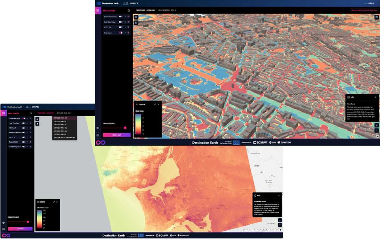
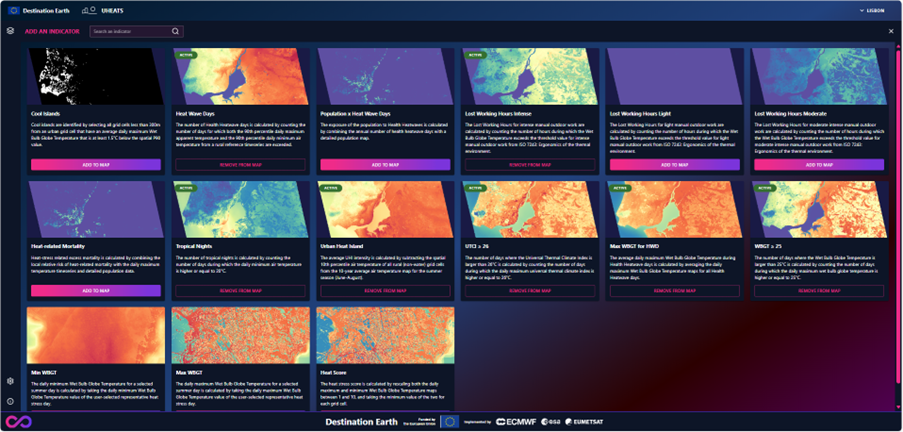
Urban Heat Indicators
The service provides indicators such as:
- Urban Heat Island intensity
- Extreme heat days
- Heatwave days
- Thermal discomfort
- Heat-related mortality risk
- Thermal comfort indicators: WBGT, UTCI, and Apparent Temperature
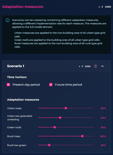
Adaptation Scenario Testing
Cities can:
- Compare present-day and future climate conditions
- Simulate and evaluate adaptation measures, including:
- Tree planting
- Urban greening
- Green roofs
- Soil unsealing
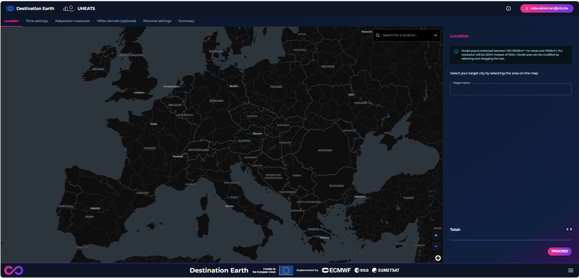
Interactive Web Platform
An operational service on the Destination Earth platform that enables users to:
- Submit requests for specific urban areas
- Define and assess adaptation scenarios
- Visualize and download datasets and maps
A Team of Experts
A team of experts gathered to demonstrate the value of the Climate Change Adaptation Digital Twin.
To achieve the ambitious goals of this contract and deliver a high-performance operational service using high-resolution projections from the Climate Digital Twin, VITO and TECNALIA have teamed up, leveraging their combined expertise and proven technical capabilities from prior European projects and Destination Earth contracts focused on heat stress.
VITO's Climate Impacts group is leading this contract, complemented by other members from VITO's Environmental Intelligence unit with expertise in quantitative assessment of climate-related impacts, and has recently successfully delivered a Earth Destination Earth use case to address urban heat island effect in Lisbon and Prague contracted by ECMWF.
TECNALIA Climate Change Adaptation team (ADCLIMA) is leading the user engagement process of this contact as they have experience developing projects for regional and local authorities related to climate resilience and has recently delivered an Adaptation Modelling Framework for Heat Stress Exposure to support the Digital Twin to develop an interactive tool to support the assessment of different adaptation strategies to minimize heat stress impacts on health in the Basque Region.
Pilot Cities
The first version of the service is already being tested in eight European pilot cities:
- Cascais (Portugal)
- Worms (Germany)
- Thessaloniki (Greece)
- Bristol (United Kingdom)
- Milan (Italy)
- Yenişehir (Turkey)
- Larnaka (Cyprus)
- Málaga (Spain)
Each pilot city selected local study areas where detailed heat-stress analyses have been performed. Results are accessible through an interactive web viewer hosted within the Destination Earth infrastructure.
Co-Creation With Cities
A strong co-creation process with cities is central to the development of the Urban Heat Service. Through webinars, workshops, and targeted stakeholder meetings, the project team gathers direct feedback from local authorities and urban planners.
The service is developed in close collaboration with major European city networks, including:
This collaborative approach helps ensure the service responds to real urban needs and supports future uptake across Europe.
Impact / What cities can explore
The Urban Heat Service enables cities to:
- Detect urban heat hotspots
- Assess future climate risks
- Understand thermal comfort at neighbourhood scale
- Evaluate the cooling impact of adaptation measures
- Prioritise investments in climate resilience
The service combines city-scale thermal maps with detailed street-level assessments, allowing planners to better understand how urban form, vegetation, and shading influence heat stress.
Technology and Destination Earth
The Urban Heat Service is developed within the European Destination Earth initiative and leverages the capabilities of the Destination Earth Data Lake and Climate Adaptation Digital Twin.
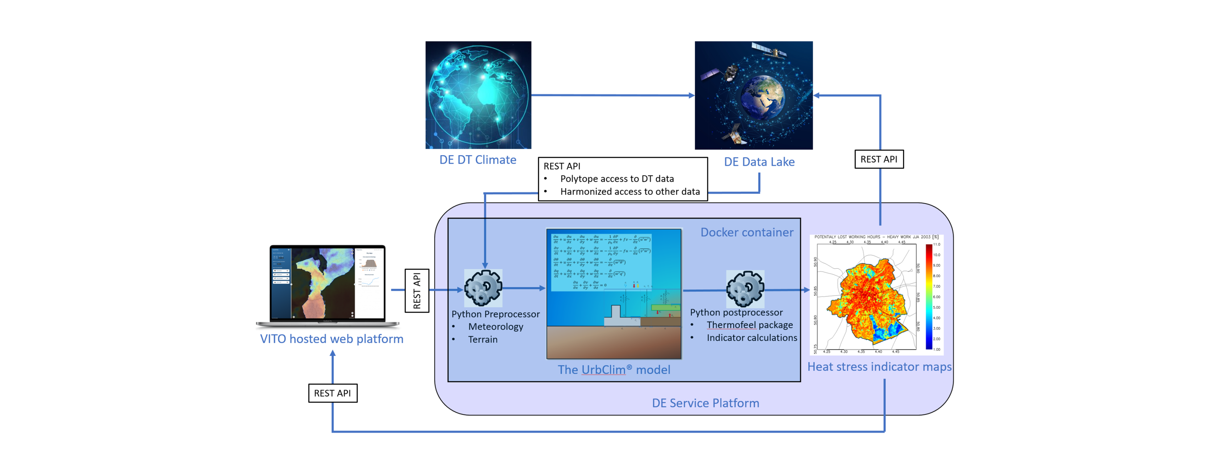
By combining climate projections with high-resolution urban modelling, the service delivers scientifically robust and operational climate information for cities.
Destination Earth is a flagship European initiative aiming to create a digital replica of the Earth system to support climate adaptation and resilience.
Facts
Implemented by VITO (coordinator) and TECNALIA
Budget: € 350.000
Funded by ECMWF within the Destination Earth Framework
Destination Earth is a European Union-funded initiative launched in 2022, with the aim to build a digital replica of the Earth system by 2030. The initiative is being jointly implemented by three entrusted entities:
- the European Centre for Medium-Range Weather Forecasts (ECMWF): responsible for the creation of the first two ‘digital twins’ and the ‘Digital Twin Engine’
- the European Space Agency (ESA): responsible for building the ‘Core Service Platform’
- the European Organisation for the Exploitation of Meteorological Satellites (EUMETSAT): responsible for the creation of the ‘Data Lake’
Learn more about Destination Earth on the European Commission website.
For more information about ECMWF’s role in the Desination Earth project, visit ecmwf.int/DestinE.