Improved access and use of climate data for surveillance and prediction of tick-borne and mosquito-borne diseases in Belgium.
Context
Vector-borne diseases are caused by bacteria, parasites and viruses that are transmitted by infected arthropod vectors, such as mosquitos, ticks, sand flies and fleas. The presence of the diseases depends on the presence of vectors and animal/human reservoirs, which is influenced by many factors, such as climate change, international travel, trade and land use.
Over the past decades, vector-borne diseases, such as those transmitted by ticks and exotic mosquitoes, have increased in Europe as well as in Belgium which demonstrates the urgent need for real-time and structured access and use of climate data to allow timely surveillance and prediction of these vectors.

Objectives
The project ‘Climate service for Belgian vector-borne disease management’ aims to develop a climate service custom-made for the “Vector-borne diseases and zoonoses” unit at the Belgian federal institute of public health, Sciensano, to address the rising impacts of climate change on public health by facilitating the surveillance and prediction of diseases related to vectors like ticks and exotic mosquitoes.
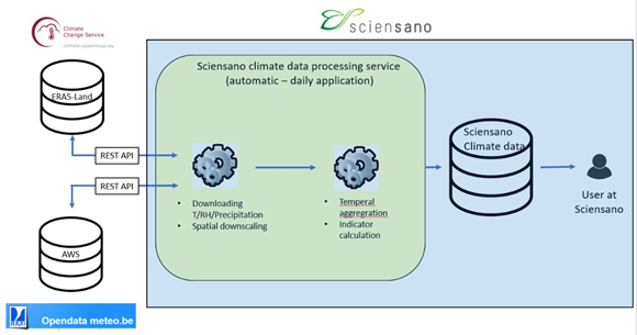
This service aims to operate in an automated way, ensuring a structured access and use of advanced and real-time climate data from the Copernicus Climate Change Service (C3S) (e.g. ERA5), and from the Automatic Weather Stations or AWS operated by the Royal Meteorological Institute of Belgium (RMIB). Real-time climate data of temperature, humidity, and precipitation will be integrated into Sciensano’s disease monitoring and prediction systems (see schematic overview above. This will enable daily updates and provide spatially detailed data that reflects urban climate variations, offering timely insights for both tick and mosquito-borne disease management.
Highlights
December 2024: Stakeholder Workshop at the Belgian Climate Centre
The first user and stakeholder workshop in December 2024 gathered over 15 stakeholders from various relevant institutions, including the Flemish Government (Department of Care and Department of Environment), the Belgian Federal Government (FPS Public Health), the Institute of Tropical Medicine, the Spatial Epidemiology Lab (ULB), the Belgian Climate Risk Assessment Centre (CERAC), and Vivalis.
The workshop introduced the technical approach, data tools, and expected outcomes of the project. An interactive session also gave the opportunity to the broader community of stakeholders working on the health and environment interface, to discuss and express their specific challenges or gaps in addressing vector-borne disease management, features or functionalities of a climate service and the use of different networks and community platforms.
November 2025: Progress and Key Achievements
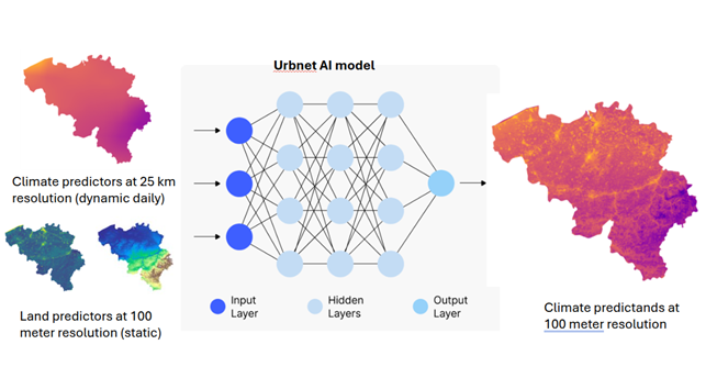
- The prototype service is operational, integrating AI-driven modelling and statistical workflows to generate near-real-time climate maps at a high spatial resolution of 100 meters.
- Initial validation results for the AI model are available, and a full workflow assessment for integration within Sciensano’s infrastructure has been completed.
Next Steps
- The service is scheduled for implementation and operational testing at Sciensano starting from January 2026, ahead of the new mosquito and tick season.
- A final stakeholder workshop is planned for autumn 2026 to present the project's outcomes.

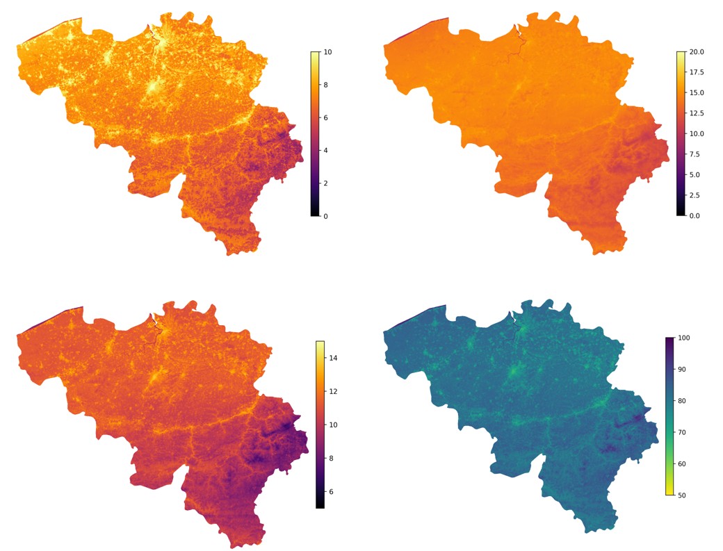
Average UrbNet output over Belgium for 2010–2020, showing daily minimum temperature (upper left), daily maximum temperature (upper right), daily mean temperature (lower left) and daily mean relative humidity (lower right). Temperature is expressed in °C and relative humidity in %.
Documentation
Facts
Budget: € 200.000
Funded by: the National Collaboration Programme of the Copernicus Climate Change Service (C3S), managed by ECMWF (the European Centre for Medium-Range Weather Forecasts)
Implemented by:
- VITO: coordinator
- Belgian Climate Centre (BCC): partner
- Sciensano: primary user and implementer
